Media Gallery


The Gran Canaria Biosphere Reserve comprehends seven of the municipalities of the island –partially in some cases, entirely in others- surprises either foreign visitors or local inhabitants.
Traditions, popular parties, people, customs, architecture, gastronomy, legends… Besides the flora, fauna and geography make an unique environment to be discovered.
Media Gallery


When approaching Puerto de las Nieves, the traditional fishing village in the northern area of the island, the abrupt coastline the visitor can see always catch an eye. Under the sun or in contrast against the blue sky some times, or surrounded by the mist others, the cliffs plunging onto the sea encourage a visit. To reach them, take the road from Agaete towards Aldea de San Nicolas and… start your thrilling journey between the cliffs and the sea while spotting the Tamadaba peaks. The native flora and fauna are the stars in an area where human impact has been diminished by the abrupt geography. From every point of the road volcanic rock cliffs can be seen, full of life, alongside with other coastal landmarks. Risco de Agaete, a little village by the road, is the last point where it is possible to rest before entering feared Anden Verde. A secret hideaway, El Charco Azul, is hidden in this picturesque place. A humble path leading to waterfalls where, coming down from the island's tops, form natural pools surrounded by big flat stones where you can sunbathe and enjoy the silence. Swimming here can be such a pleasure. Sea waters are also, in this coastal strip, part of the Biosphere Reserve of the island. The El Risco beach, walking down to the coast from the homonymous village, or Guayedra beach are the most renowned and accessible. This last one can be reached through a palm-tree grove and walking down a ravine. Not many people use to go there and the water, even when alluring, is rough, so it is important getting to know the area before swimming.
Media Gallery


This municipality is entirely within the Biosphere Reserve. Reaching "La Aldea", name popularly given to the main village, is an impressive tour whether if you come from the South, via Mogan, or from the north, through Agaete. Imposing cliffs running from the Tamadaba and Inagua tops form ravines running to the sea. The Tasarte and Tasartico ones, in the Mogan route, are examples of these and arrive to small beaches where going for a swim is always a well received idea. The coastal line and the sea strip of the municipality are also part of the Biosphere Resreve and is packed with coves and beaches, although the abrupt geography sometimes blocks the pedestrian access. Guguy (also known as Güi-Güí by the locals) is one of the most famous and beautiful and as getting there on foot means walking for many long hours through a rough way under the sun, it remains unspoilt and full of natural riches. The access from the sea from La Aldea, Agaete or Mogan is the most frequently used way by those who want to know this beach, although the most adventurous ones can choose to go with the fishermen in their vessels or dare to reach it on foot. The experience will be unforgettable, intense and definitely stunning. Camping is not allowed and visitors are always reminded not to litter the area so the beach would continue being a hideaway full of magic, beauty and biodiversity. Once you reach the La Aldea village, where agriculture has always been the most remarkable activity, you will breath tradition. Walking through its alleys searching for the Balcony House, the Cultural Centre, the church and the Town Hall will provide us with a general idea of how the village is laid out nowadays. In their turn, the windmills and the living museums will depict the past. Collections of ancient tools and customs explained by the elderly become true ethnographic and anthropologic traces of this past.
La Aldea, aware as it is of its long distance from other villages, offers hospitality in its hotels, cottages and inns where the visitor can stay and taste calmly before making the way back the traditional dishes of the area, such as the octopus stew known as ropa-vieja de pulpo or the delicious local artisanal cheese.
By visiting the El Roque Ecotouristic Marine Micro Area, located also in the village, you will learn everything about the sea biodiversity in the area and maybe will feel encouraged to take part in some of the seawater friendly activities they organize.
Media Gallery


The volcanic landscape dubbed "petrified storm" by the nineteenth century writer Miguel de Unamuno is still surprising nowadays to those who come by to gaze at it from the viewpoint named after him or from the ‘La Cilla' viewpoint which can be accessed through a gallery dug in the rock.
This municipality's territory, stretching out entirely within the Biosphere Reserve, revolts around its pivotal point in the cozy San Matias church square. Its little bars and terraces are meeting points for locals and visitors, and there, once a month, a little agriculture and handicrafts market takes place.
Visiting the Virgin of the Cave chapel, patron of cyclists and traditional folk groups, is a must-do visit in Artenara. Fully carved on volcanic rock, it shows the layout of the cave dwellings disseminated over the hills of the municipality. Home to many families from the aboriginal times to our days, a visit to the Cave-Dwelling Museum helps to understand how these places at the heart of the mountain used to be and still are today. Outside the old village centre, Acusa Seca or the Risco Caido caves are clear proofs of the importance this area had for the island aboriginals. The well known Tamadaba pine forest, a large Canarian pinetree woods bordered by spectacular cliffs over the north coast, is another must visit spot, preferably at sunset, as watching the sun from this point will be an unforgettable moment.
Media Gallery

The municipality of Mogan, one of the places on earth with a larger number of sunny days per year, owns its sea strip fully integrated in the Gran Canaria Bisophere Reserve. The orography of the sea bed jointly with the underwater animal and vegetal biodiversity make the area exceptional. The sea has always played a significant role and there is archeological evidence proving that in the coast of the existing Mogan harbour area ancient inhabitants made a living on the sea and on fishing from ancient times. The aborigine archeological site Lomo los Gatos witnessed these activities and is well worth a visit as, besides the thrilling history surrounding the place, stunning views of the sea and the coast are to be enjoyed.
Also seen from the sea, the spectacular Tauro massif drives the running waters from the island tops forming the Tauro, Taurito or Mogan ravines amongst others. The massif is also part of the Biosphere Reserve as it keeps several animal and vegetal autochthonous species and a jewel threatened with extinction: the Gran Canaria dragon tree (Dracaena tamaranae). This species, adapted to arid and volcanic lands, scarce on soil and water supply, picked the most inaccessible spots to thrive, far from places where human impact has been stronger.
Following the road from the coast inwards you will reach the village of Mogan. Small and picturesque, it is located in the middle of a beautiful landscape.
Bars and restaurants in the centre of town are always packed with locals who, accustomed to welcoming visitors, have no objections in sitting down and have a chat about the present and the past of the area.
The Mogan windmill, known as Molino Quemado (‘the burnt mill'), names the little group of houses located right before reaching the village of Mogan. It is an old 19th century windmill which, according to some, was set fire by one of the villagers as a protest against some town council decisions.
Rebuilt by that same town hall, the mill was responsible for the flour supply in the area and today is a landmark in the community.
Media Gallery


Internationally famous for its beaches, this municipality also accounts with part of its territory at the island's top treasuring unique features within the Biosphere Reserve territory. The superb Tirajana cliffs are home to endless natural and human riches. Small rural areas such as Risco Blanco prove the harmonic coexistence of man and nature. The municipality main town, known for its aboriginal name, Tunte, is also located at the feet of these cliffs. It is a village full of true Canarian atmosphere where rural life can be experienced, a village also visited by the thousands of tourists who visit the Maspalomas coasts every year. The area is full of roads and routes for the practice of trekking, so there are many B&B cottages and some countryside hotels to host hikers and nature lovers. From the Maspalomas beach, driving up through San Fernando towards Fataga, there is a viewpoint from where the Amurga massif can be admired. This rock formation, between the Tirajana and Fataga ravines, was important to the aboriginal population as a sacred area used to worship the stars from a high point. From the viewpoint you can also contemplate the Fataga palm tree grove, a dense Canarian palm group right in the middle of an arid and rough landscape. Moving forward on the road, and before reaching the grove you find Arteara. It is a small group of cottages hiding an archaeological site well worthwhile: the Arteara necropolis.
Following that same road you will reach Fataga, cute traditional village perfect to take a break in the journey and sample the gastronomy of the area or buy a typical souvenir. Moving forward again, at the Fataga heights you can find the Cazorla watermill, a Cultural Heritage site. The Pilancones Natural Park, with over 5,700 hectare wide, is crossed by many hiking paths, some of them very difficult at some points, allowing to enjoy the Canarian pinetrees, other autochthonous vegetal species and birds such as the ‘pico-picapinos' (pinetree-woodpecker), which hammering sound will accompany the walker, or the Gran Canaria blue finch, threatened with extinction and beneficial of a recently approved Recovery plan. Fully integrated in the Biosphere Reserve, the park lost its emblematic icon, a huge pine-tree over 500 years old, to a fire occurred in July 2007.
Media Gallery


Notorious top-of-the-island municipality, Tejeda is in its full extension part of the Biosphere Reserve and the Tejeda village has recently been awarded one of the most beautiful villages in Spain. Tourists and locals come on a daily basis to see the stunning Nublo and Bentayga rocks views from Tejeda. The village counts with numerous hotels, self-catering cottages and apartments, and has lots to offer: the church and its square, the Medicinal Plants Centre, the Museum of the Traditions, etc.
The gastronomy in the area can be sampled at bars and restaurants in the village or at the Cruz de Tejeda (Tejeda Cross), where a National Parador (lodging establishments network formerly owned by the Government) and many little souvenir and local handicraft shops can be found, aside with restaurants and its typical dishes. In Tejeda every meal must be accompanied with the famous almond delights. The almond-trees, spread all over the area, are a superb visual treat when these bloom and many hikes are organized to enjoy them. At the beginning of February every year the traditional Almond-tree Blossom Party takes place, with people from all over the island attending on their folk costumes.
A road leaving from the village reaches the Bentayga Rock and its interesting Information Centre where you will discover the rites performed by the ancient aboriginal population, the canarios, at the feet of this sanctuary. This rock of volcanic origin is, alongside with the Nublo Rock –Gran Canaria's icon-, the rocks known as El Monje (‘the friar') and La Rana (‘the frog') form the top of Gran Canaria's skyline. In fact, there are many points from which these rocks can be seen from different perspectives, being the Degollada de Becerra viewpoint one of the most popular for its unforgettable sunsets.
Media Gallery

San Mateo is a clear example of what in the Canaries is called "the midlands": an area located between the sea and the islands' tops. The Gran Canaria midlands, humid and rainy in the winter and dry and hot in the summer, are perfect for growing vegetables and cattle. But San Mateo also reaches the island tops. A small strip at the top lies within the Gran Canaria Biosphere Reserve in one of its transition areas. It is a pine tree forest located close to Pico de las Nieves and its snow well.
From Las Lagunetas neighborhood many hike paths start, interesting and loopy, returning to the same place, being perfect for a proper rest after the effort and to get back in track with the gastronomy, wines and cheese of the area offered by its bars and restaurants. The La Mina ravine is another point of special interest in the village, as a very interesting group of Canarian willows known as saos, frequent in the humid waterbeds in the northern face of the island, can be found.
Mapas
- Mapa Reserva de la Biosfera
- Reserva Biosfera sup. total.kml
- Senderos clasif. Reserva Biosfera GC.kmz
- Senderos:
- Zona Agaete Artenara Cruz de Tejeda (Descarga mapa en alta calidad)

- Zona Cruz de Tejeda Tunte (Descarga mapa en alta calidad)

- Zona Cruz de Tejeda Valleseco Teror (Descarga mapa en alta calidad)

- Zona Garañón Las Presas Tunte (Descarga mapa en alta calidad)

- Zona Garañón San Mateo (Descarga mapa en alta calidad)

Asset Publisher
What Are These?
A Biosphere Reserve is an area comprising singular characteristics and formed by terrestrial, marine, coastal or mixed ecosystems, where solutions to reconcile biodiversity conservation and sustainable use of resources are promoted. These areas, internationally recognized by the UNESCO Man and the Biosphere Programme MAB constitute "support sites for science and sustainability".
Where Are These?
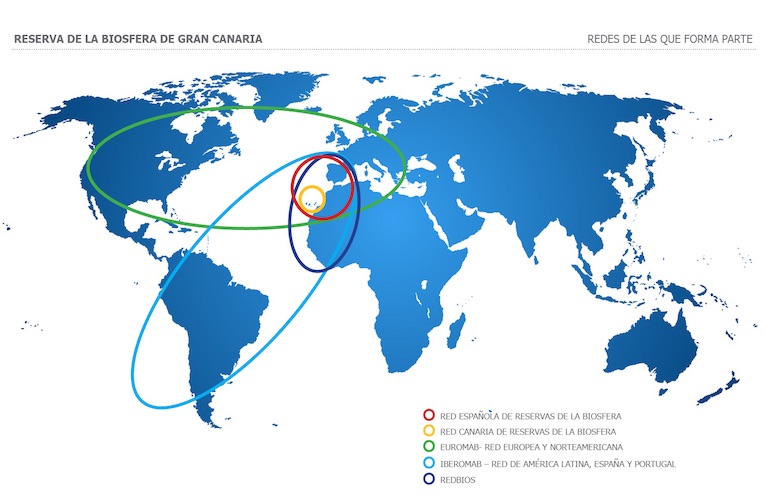
The 631 World Biosphere Reserves Are Spread Over 120 Countries Comprising A Total Area Of Over 700 Million Hectares (2015).
These Are Distributed As Follows:
67 Biosphere Reserves In 28 Countries In Africa
136 Biosphere Reserves In 24 Countries In Asia And The Pacific
29 Biosphere Reserves In 11 Countries In The Middle East
297 Biosphere Reserves In 36 Countries In Europe And The United States
122 Biosphere Reserves In 21 Countries In Latin America And The Caribbean
Download The World Biosphere Reserves Map
What Are These For?
The Main Goals To Accomplish By The Biosphere Reserves Are To Promote And Boost The Harmonic Integration Of Human And Nature To Achieve Sustainable Development For Each Of These. In These Areas, Specially Designated In Order To Test Multidisciplinary Approaches, Tasks Are Carried Out Through Participative Dialogue, Research, Knowledge Exchange, Poverty Diminishing, Wellbeing Improvement, Respect For Cultural Values And Social Ability To Adapt To Environmental And World Changes.
How Do These Work?
Activities
The Activities To Be Conducted By The Biosphere Reserves Can Be Summarized In Three: Conservation, Development And Logistics. The First One Will Try To Preserve And Improve The Natural Values Attached To It; The Second One Is Based On Reaching The Socio-Economic Development Of Local Populations Present In The Territory; The Logistic Activity Is Intended For The Research, Education And Experience Exchange Between The Human Being And The Environment.
Work Procedure
From The Starting Point Of Working In A Cooperative Way Under A Wide Alliance As The Only Means To Obtain Sustainable Results In The Long Term, The World Network Of Biosphere Reserves, Alongside With International Bodies, Governments, Local Public Offices, Universities, Ngos And Corporations Worldwide, Works Supported By Other Several International Networks, National, Regional, Municipal And Sectorial.
Besides This General Framework Described, Each Biosphere Reserve Develops An Action Plan Which, Designed For Specific Periods, Sets Out The Tasks To Be Carried Out. Such Plan Must Be Approved By All Members Of The Respective Councils.
Territorial Structure
Each Biosphere Reserve Is Made Out Of Three Interrelated Areas With Connected Roles, Complementary And Mutually Reinforcing:
• The Core Zone, Where The Most Remarkable Natural Values Concentrate, Being The Conservation Function The Reigning One.
• The Cushion Zone, Surrounding The Core, Or Adjoined To It, Where Activities Compatible With Successful Ecologic Practices That Can Contribute To The Research, Follow-Up, Training And Scientific Education.
• The Transition Zone, Where A Wider Range Of Activities Are Promoted In Order To Contribute To A Sustainable Human And Economic Development From The Social, Cultural And Ecologic Point Of View.
Who Do These Depend On?
The Inclusion Of A Specific Area In The World Network Of Biosphere Reserves Occurs When A Decision Is Made By The International Coordinating Council Of The Mab Programme (Man And Biosphere) According To The Candidacies And Proposals Conveyed By The Governments, Whereas The Jurisdiction Over The Area Designated As Biosphere Reserve Lies Entirely On The Country Where It Is Located.
The Intergovernmental Structure Of Unesco Through The Mab Programme Provides The Governments With The Framework For The Planning And Carrying-Out Of Research Programmes And Training, Supplying Technical Assistance And Scientific Advice.
The Signing Countries Constitute Mab National Committess Which Guarantee The Widest Participation Of Countries In The International Programme, Defining And Carrying Out Its Activities In The Mab International Coordination Council, Main Governing Body For Mab, Which Sets Out The Agenda Of The Programme.
Concurrently, And To Attain The Effective Synergies In Order To Share Knowledge And Work Experiences, Networks Clustering Biosphere Reserves Under Geographic Criteria (Regional And Sub-Regional Networks) Or By Ecosystems And/Or Shared Features Are Constituted.


![english [beta] english [beta]](/o/biosferagc-theme/images/language/en_GB.png)

